Jul 4, 2010


Benny and Elmer(banjo) and a Canadian fella Richard camped next to us jamming.


These are the Hopewell Rocks. The Bay of Fundy has the largest tides in the world. These rocks are being worn away by the tides. Benny and I are standing under part of the sandstone worn away by the tides.


The Hopewell Rocks at low tide. The arch in the large rock is what Benny and I were standing under. It is neat to be able to walk on the ocean floor.


The Hopewell Rocks at high tide. The large rock in the center is what Benny and I stood under at low tide. Quite an awsome sight in person. We are at Lower Cape, NB. Tomorrow, July 5 we move on to new adventures.

Today, June 30, we drove the Fundy Trail. Today it is a lovely area of coastline and lots of birch trees as well as black spruce and spruce trees. From 1850-1924 it was heavily logged and there was a sawmill. It has since been protected and is now the Fundy Trail with driving trails as well as hiking and biking trails. This picture is called the flower pot--sandstone rock with trees growing on top.


Benny and I next to Fuller Falls.
Saint John, NB is the only city on the Bay of Fundy. It was established in 1783 by Acadians, Loyalists, and Irish. This picture is typical of the downtown area. These buildings date from the early 1800's.


In the center of downtown is Kings Square named in honor of King George VII. It has picnic tables, benches, statues, and beautiful gardens like this one.


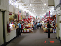
The city market in downtown. It has groceries, fresh breads, restaurants, and tourist items all under one roof.


The Anglican Church dating from 1783.


Reversing rapids. This picture is taken at high tide when water is coming from the Atlantic Ocean through the Bay of Fundy into the St. John River.


This picture is taken at low tide when water is coming from the St. John River into the Bay of Fundy. This picture is the same rock as the one above.

Jul 3, 2010

Our anniversary, June 27, 2010. We enjoyed a fresh lobster dinner with our friends and travelmates Elmer and Barbara Tornquist.


New Brunswick has many covered bridges. These are just two in St. Martins, NB.


The Caves--sandstone washed away by the tides. Benny and Jeanne showing you how big it is.


The Caves with the tide in.
The view from our motorhome at St. Andrews on the Sea. This was my view every morning with my coffee.


St. Andrews by the Sea, New Brunswick, is one of Canada's oldest seaside resort towns--founded in 1783 by people loyal to the king of England (loyalists). We arrived on June 22 and left on June 26.


This is the blockhouse-- built for protection from the Americans during the War of 1812.


This is the map of the Fundy Coastal Route(green line) we are following at present. It has taken us from the border at St. Stephens, New Brunswick to where we will catch the ferry to Newfoundland. We are following the Fundy Bay which is the narrow bay between New Brunswick and Nova Scotia.


Benny with Scrappy and Jeanne with Hansel begin our adventure through Eastern Canada and the Maritime Provinces in our motorhome.